


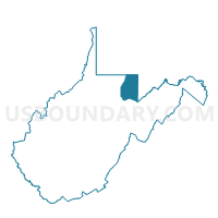
Voting District 3, Preston County, West Virginia
About
Outline

Summary
| Unique Area Identifier | 691706 |
| Name | Voting District 3 |
| County | Preston County |
| State | West Virginia |
| Area (square miles) | 31.38 |
| Land Area (square miles) | 31.36 |
| Water Area (square miles) | 0.02 |
| % of Land Area | 99.93 |
| % of Water Area | 0.07 |
| Latitude of the Internal Point | 39.67065210 |
| Longtitude of the Internal Point | -79.51205060 |
Maps


Graphs
Select a template below for downloading or customizing gragh for Voting District 3, Preston County, West Virginia


Neighbors
Neighoring Voting District (by Name) Neighboring Voting District on the Map
- Voting District 2, Preston County, WV
- Voting District 6, Preston County, WV
- Garrett Precinct 02-001, Garrett County, MD
- HENRY CLAY TWP Voting District, Fayette County, PA
- WHARTON TWP DIST 02, Fayette County, PA
Top 10 Neighboring County Subdivision (by Population) Neighboring County Subdivision on the Map
- Second district, Preston County, WV (8,708)
- Wharton township, Fayette County, PA (3,575)
- Henry Clay township, Fayette County, PA (2,066)
- District 2, Friendsville, Garrett County, MD (1,924)
Top 10 Neighboring Unified School District (by Population) Neighboring Unified School District on the Map
- Preston County School District, WV (33,520)
- Garrett County Public Schools, MD (30,097)
- Uniontown Area School District, PA (23,820)
Top 10 Neighboring State Legislative District Lower Chamber (by Population) Neighboring State Legislative District Lower Chamber on the Map
- State House District 51, PA (56,731)
- State Legislative Subdistrict 1A, MD (39,216)
- State House District 45, WV (22,068)
Top 10 Neighboring State Legislative District Upper Chamber (by Population) Neighboring State Legislative District Upper Chamber on the Map
- State Senate District 32, PA (225,580)
- State Senate District 14, WV (121,969)
- State Senate District 1, MD (118,930)
Top 10 Neighboring 111th Congressional District (by Population) Neighboring 111th Congressional District on the Map
- Congressional District 6, MD (738,943)
- Congressional District 9, PA (666,810)
- Congressional District 1, WV (615,991)
Top 10 Neighboring Census Tract (by Population) Neighboring Census Tract on the Map
- Census Tract 9638, Preston County, WV (6,763)
- Census Tract 9641, Preston County, WV (4,563)
- Census Tract 1, Garrett County, MD (4,003)
- Census Tract 2627.01, Fayette County, PA (3,575)
- Census Tract 2627.02, Fayette County, PA (3,140)